Candy Cane Mountains: finding Azerbaijan's striped hills near Khizi
Khizi · about 1.5 to 2 hours from Baku
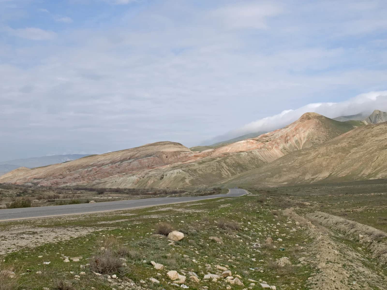
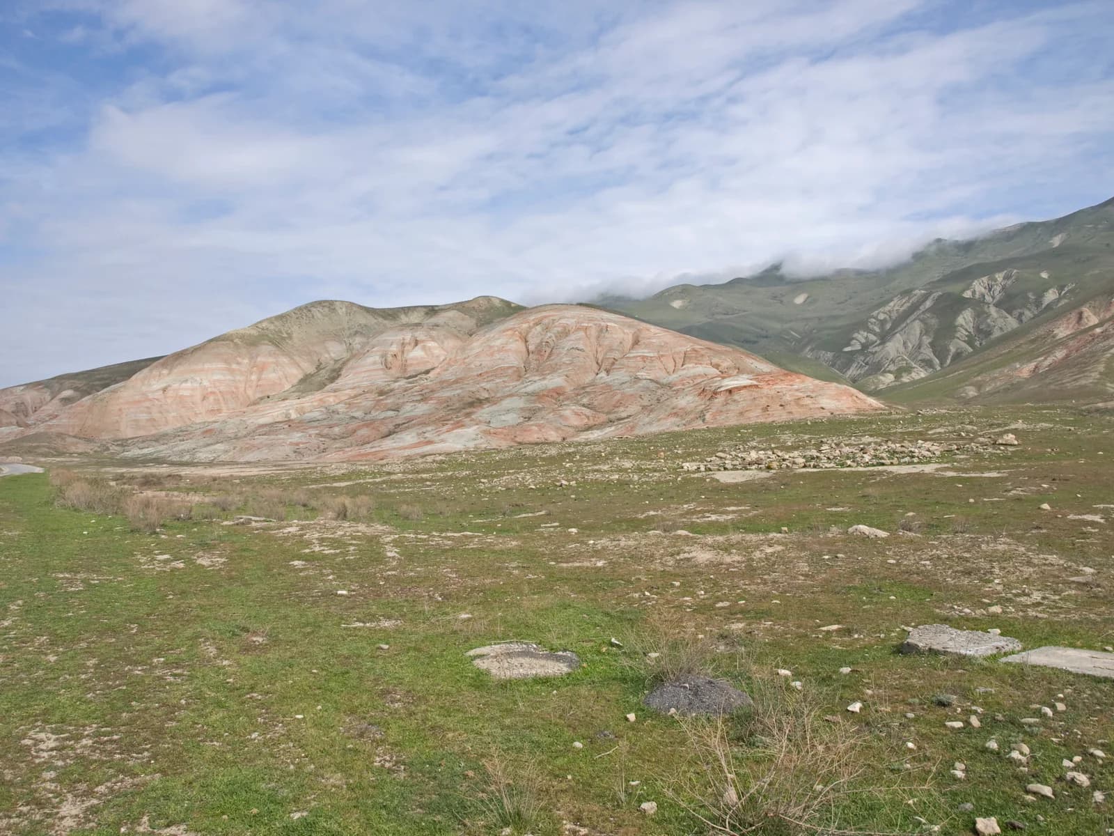
The Candy Cane Mountains are a band of red-and-white striped ridges spread along the Baku to Quba highway and the Khizi road, around the Khizi and Siyazan district boundary about 100 km north of Baku. The colours come from alternating iron-rich and pale sedimentary layers. The name is a guidebook coinage rather than an official toponym, there is no gate, signage or ticket office, and the hills are explored from roadside pullouts or, deeper in, on dry riverbed tracks by 4x4.
- Region
- Khizi
- From Baku
- 100 km · about 1.5 to 2 hours
- Best season
- Spring and autumn for soft light; year-round in dry weather
- Time to spend
- 1 to 2 hours at the hills; half a day as a loop from Baku
- Entry
- No formal entrance. Re-checked on 11 August 2026: no state body publishes a tariff for the hills, they appear on no reserve ticket list and no session is sold through iTicket.az. A small roadside charge of about 2 AZN turns up in some accounts and is contradicted by others, so carry a few manat in coins rather than counting on either version.
- Hours
- No gate and no hours. This is open ground reached from a public road, so daylight and dry weather are the only real limits. There are no facilities of any kind: no water, no shade, no toilets, no cafe.
- Red-and-white banded ridges unlike anywhere else in the country
- No gates, no ticket office, no crowds: open ground you explore freely
- Roadside viewpoints reachable by any car in dry weather
- Dry wadi tracks behind the front ridges for 4x4 exploration
- An easy pairing with Altiaghaj National Park or Beshbarmag rock
- A stop that sits on the Baku to Quba corridor, so it costs almost no detour
The Candy Cane Mountains are the most photographed hills in Azerbaijan that nobody can give you directions to. Every guide says "near Khizi", none says where to stop, and there is no sign on the ground to help. The short version: drive the Baku to Quba highway about an hour north of the capital and the banded ground starts showing around the Khizi and Siyazan district boundary, with the deeper ridges spread along the road inland toward Khizi and Altiaghaj. Birtour, a Baku-based DMC, crosses them on dry wadi tracks as day 4 of our 4x4 expeditions. The notes below cover both the easy version and ours, re-checked on 11 August 2026.
Where exactly are they, and why can't anyone say?
Because they are not one summit with a car park. The banded ground runs across several kilometres around the Khizi and Siyazan district boundary, showing first from the Baku to Quba highway and continuing along the road inland. The road itself is the viewpoint: once the stripes begin, pull off where the ground is firm and walk.
The strongest amphitheatres sit behind the first ridgeline, off the asphalt, reached on dry riverbed tracks. Use firm roadside pullouts and confirm off-road access for the specific departure. This page does not publish unverified GPS coordinates for the tracks.
The hills also turn up on a route most readers of this page would not expect. Hankyu Travel's six-day Azerbaijan package, sold in Japan around the second season of the TBS drama VIVANT, stops here, and a coach party sees the striped ridges from the road rather than from the wadi network below. Hankyu labels the hills one of six filming locations, on its own authority. Our VIVANT in Azerbaijan page sets out who has named which places, and on whose authority.
Is "Candy Cane Mountains" the real name?
No. It is a guidebook coinage, credited to the travel writer Mark Elliott, not an official Azerbaijani toponym. You will not find it on a state map or a road sign, and asking for it by that name in Khizi town gets you a blank look. It also names a series of separate hills rather than one mountain.
That matters more than it sounds. The reason no source can hand you a pin is that there is no single feature to pin: the name was applied to a stretch of striped country by an outsider, adopted by Instagram, and never adopted by anyone with authority to define its edges. Once you know that, the vagueness in every guide stops reading as laziness and starts reading as the honest answer.
Does anyone charge to visit?
No formal entrance exists. Re-checked on 11 August 2026: no state body publishes a tariff for the hills, they appear on no reserve ticket list, and nothing is sold through iTicket.az. Some accounts mention a small roadside charge of about 2 AZN and others report walking in for nothing.
Carry a few manat in coins and treat either outcome as normal. What is certain is that there is nothing to pay for: no water, no shade, no toilets, no cafe, no ranger. Fuel and food are on the Baku to Quba highway, not up the mountain road, so top up before the turn rather than counting on finding anything after it. Take your litter back out; there is no bin and no one to empty it.
What makes the stripes?
Alternating sedimentary layers. Iron-oxide-rich bands weather red and rust-pink, paler clay and carbonate bands stay white and grey, and erosion has sliced the stack at an angle that reads as candy striping. The colours are moisture- and light-sensitive rather than fixed, which is why two visitors describe the same ridge differently.
Low morning or late-afternoon sun deepens the reds. A recently dried surface after rain gives the strongest contrast of all, while wet ground both dulls the colour and makes the clay treacherous to drive. Midday sun flattens the banding into something much less interesting than the photographs promised, which is the single most common disappointment we hear about this stop.
Any car, or a 4x4?
Dry weather and the classic roadside views: any car, no drama. The deeper wadi tracks, and any visit within a day or two of rain, are 4x4 territory. Wet Khizi clay is genuinely slippery, the kind that stops two-wheel-drive cars on flat ground, and there is no recovery service out there to call.
If you rent and go independently, use the driving in Azerbaijan checklist to ask whether the exact tracks and surfaces are permitted and what the contract says about tyres, underbody and recovery. Do not treat an SUV listing as permission to leave the paved road. On the 8-day 4x4 self-drive expedition the hills are the reward at the end of the long day 4 transit: roughly 30 km of wadi tracks through the ridges, then a field picnic at the White Spring (Ag Bulaq) before the night in Altiaghaj.
Where does the day sit in the expedition week?
Between the forest and the high mountains, and the placement is deliberate. Day 4 is the longest transit of the week, about 360 km and 6 hours of driving, most of it asphalt, descending from the Talysh range and running north past Baku before the climb into the Khizi hills.
On our route sheet the wadi network rates easy to moderate: the gentlest genuinely rewarding off-road in the country, and the best photography-per-effort ratio we run. That gentleness is the design. The next morning the convoy leaves Altiaghaj for Quba and the Khinalig day at 2,350 m, the hardest driving of the route, so the striped hills are the easy day in exactly the right place.
What is the Baku to Quba highway like?
Better than it was, and no longer free. A 66 km stretch of the M-1 between km 53 and km 119, covering the approach to the Khizi turn, had its failed concrete pavement relaid in asphalt-concrete and reopened in June 2026. A separate 129 km section north of the H.Z. Tağıyev settlement is now a toll road by Cabinet decision.
Speed enforcement on that highway is camera-first, densest on the approaches to the capital, and fines attach to the vehicle rather than the driver. On a rental they reach you through the rental company, often after you have flown home, with a handling fee added. Ride the posted limit through the villages, where the 50 km/h zone starts earlier than the houses do, and treat every overhead gantry as live.
What can you pair it with?
Altiaghaj National Park continues up the same road, and Beshbarmag rock stands off the coastal highway on the way back, which makes a natural half-day loop from Baku. Beshbarmag has sat on Azerbaijan's UNESCO tentative list since 1998, as "Baku Stage" Mountain, and has never been inscribed, which is worth knowing before a guide upgrades it for you.
The better pairing for anyone heading further is simply north. The hills sit on the Baku to Quba corridor, so a stop here costs almost no detour on the way to Quba and Khinalig, and it breaks up what is otherwise a four-hour drive with nothing to look at. For a group with one free day and no interest in unpaved surfaces, our Gobustan and Absheron fire day is the better use of the time, and we would rather say so than sell the wrong day out.
What we would not recommend
Three things. Do not come at midday, for the reason set out above. Do not drive the wadi tracks within a day or two of rain in anything without low range. And do not build a whole day around this stop: one to two hours at the hills is the honest figure.
The last one is the mistake we see most often in self-planned itineraries. The visit works as part of a loop and falls apart as a destination in its own right, because there is nothing here to occupy a group beyond the walking and the light. Plan it as the good hour inside a longer day north.
What stays open when the high routes close?
From November to April the high routes shut in practice: snowfall closes the Khinalig road for days at a time, the Laza track under Shahdag is done for the season, and the Talysh clay turns to mud. The Khizi hills stay in the workable lowland tier, with the roadside viewpoints reachable between weather systems all winter.
They sit alongside the Gobustan mud-volcano approach in that tier, which is the pairing we reach for when a February group wants a landscape day and the mountains are shut.
The caveat never moves, though. Wet clay closes the wadi tracks in any month, so a January visit is a viewpoint visit unless the week has been rainless. For the seasonal status of every route we run, the 4x4 routes index carries the full table.


- Where exactly are the Candy Cane Mountains?
- They spread around the Khizi and Siyazan district boundary, about 100 km north of Baku: the first banded ground shows from the Baku to Quba highway itself, and the ridges continue along the road inland toward Khizi and Altiaghaj. There is no sign, no gate and no single official viewpoint, which is why directions in most guides sound vague.
- Is there an entrance fee for the Candy Cane Mountains?
- There is no formal entrance and no published tariff, re-checked on 11 August 2026: no state body lists the hills, and nothing is sold through iTicket.az. Some accounts mention a small roadside charge of about 2 AZN and others report walking in for nothing, so carry a few manat in coins. There are no facilities to pay for either way.
- How do you get there from Baku?
- Drive the Baku to Quba highway north for about an hour, then either stop where the banded ground first shows near the district boundary or take the signed turn toward Khizi and Altiaghaj for the deeper ridges. Allow 1.5 to 2 hours each way. There is no public transport to the hills; a car, a driver-guide day trip, or a 4x4 tour are the practical options.
- Do you need a 4x4 for the Candy Cane Mountains?
- Not for the classic views: in dry weather any car reaches the roadside pullouts. A 4x4 earns its keep on the dry riverbed tracks behind the front ridges, where the best striped amphitheatres hide, and after rain, when the clay surface turns greasy enough to stop two-wheel-drive cars completely.
- Why are the hills striped red and white?
- The banding is sedimentary: layers rich in iron oxides weather red, alternating with paler clay and carbonate layers, and erosion has carved the stack into ridges that read like candy stripes. Colour intensity shifts with light and moisture, strongest in low sun and just after the ground dries from rain.
- Is Candy Cane Mountains the real name?
- No. It is a guidebook coinage, credited to the travel writer Mark Elliott, not an official Azerbaijani toponym, and it will not appear on a state map or a road sign. It also describes a series of separate hills rather than one mountain, which is the second reason nobody can give you a single set of coordinates for it.
- What is the best time of day to see the stripes?
- Early morning or the last two hours before sunset, when low sun deepens the reds. The strongest contrast of all comes a day or two after rain, once the surface has dried but the colour has not bleached back out. Midday sun flattens the banding, which is why so many photographs look better than the visit did.
- What can you combine with a visit?
- Altiaghaj National Park continues up the same road, and Beshbarmag rock stands off the coastal highway on the way back, which makes a natural half-day loop from Baku. The hills also sit on the Baku to Quba corridor, so they cost almost no detour on the way north toward Quba and Khinalig. On our 8-day 4x4 expedition they are day 4: wadi tracks through the ridges, then a field picnic at the White Spring.
Itinerary
Azerbaijan 4x4 self-drive expedition: 8 days, Talysh to Greater Caucasus
Guide
Azerbaijan 4x4 routes: an index of tracks, seasons and difficulty
Guide
Driving in Azerbaijan: licence checks, fuel, borders and route choice
Destination
Khinalig village: visiting Europe's highest continuously inhabited settlement
Experience
Gobustan, Mud Volcanoes & Absheron Fire Tour from Baku